File formats / User point formats
User point formats category in File formats folder contains a list of user-defined point formats. You can define your own formats which can be used for the input or output of point data. The software can read any text files where each row contains the information of one point and the point attributes are organized in columns (fields). The file format definition determines what fields are included for each point and what is the order of the fields.
The text file formats may contain delimited fields or fixed length fields. The delimiter can be comma, space, tabulator, or semicolon. A fixed length fields is defined by constant column widths and positions in each row.
You can Add, Edit, and Delete point formats by using the corresponding buttons in the Settings dialog. The Copy button creates an identical copy of a selected format definition. The Move up and Move down buttons change the order of formats in the list.
The following attributes can be imported/exported from/to text files:
•No field - no field defined in the text file.
•Ignore - the column in the text file is ignored. This applies only for importing text files into TerraScan.
•Easting, Northing, Elevation - XYZ coordinates.
•Longitude, Latitude - position in degrees, minutes, and seconds.
•Class - class number.
•Code - class code. Can be defined in the Define classes dialog of TerraScan.
•Echo type - echo type as text string. Possible values are 'First', 'Last', 'Intermediate', and 'Only'.
•Index - unique number for each point.
•Intensity - intensity value as integer.
•Line - line number.
•Time - time stamp.
•Collection - number of collection shape. Only used with Output collections command for projects (Not UAV).
•Group - group number. Can be assigned automatically to point groups by using the Assign groups commands or macro actions, or manually by using the Create point group tool.
•Surface dz - difference between a point and a TerraModeler surface. This requires that a surface model is loaded into TerraModeler.
•Red 8|16, Green 8|16, Blue 8|16 - RGB color values. The number determines the color depth which can be either 8-bit or 16-bit. Color values can be assigned to points by using the Extract color from images command, or the Assign color to points command or macro action.
•Echo number - echo number as number.
•Number of echoes - total number of echos at the position of a point.
•Scan angle - scan angle in degree or integer units as defined in LAS 1.4 file format. Select the correct format in the Scan angles selection list that appears in the dialog if the attribute is selected for one of the fields. Degree values must range between -128 to +127.
•Scanner - scanner number.
•Image - image number. An image number can be computed and stored for points if the corresponding setting in the Extract color from images command is set.
•Distance - distance value computed with the Compute distance command or macro action.
•Echo length - echo length value. The value can be extracted from waveform information in TerraScan using the Extract echo properties command. It can also be provided system-specific, such as by Riegl Extra Bytes attribute Pulse width.
•Amplitude - amplitude attribute value. The value may be set from an attribute of a system-specific point format, such as Riegl Extra Bytes in LAS files.
•Reflectance - reflectance attribute value. The value may be set from an attribute of a system-specific point format, such as Riegl Extra Bytes in LAS files.
•Dimension - dimension attribute computed with Compute normal vector command or macro action.
•Normal X, Normal Y, Normal Z - XYZ normal vector components computed with Compute normal vector command or macro action.
•<Extra attribute> - custom Extra attribute.
To define a new point format:
1. Open the User point formats category in the File formats folder.
2. Click Add in the Settings dialog.
The File Format dialog opens:
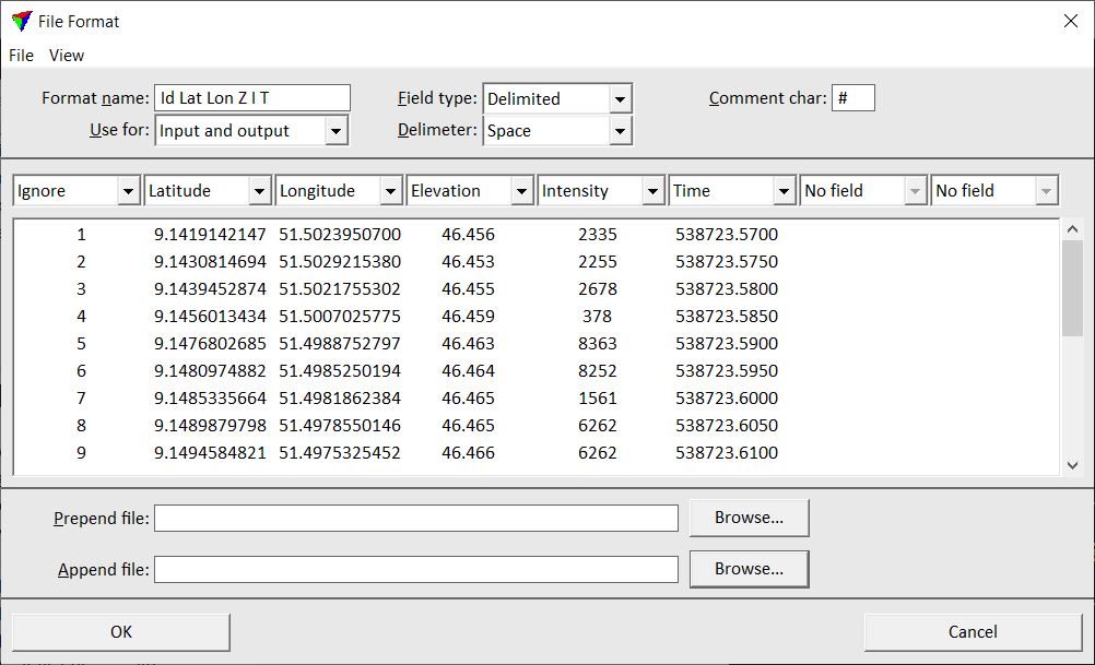
3. (Optional) Select Load example command from the File pulldown menu of the File Format dialog. Select an example file of the format you want to define.
This reads the first lines of the text file and shows its content in the field list. The software also tries to detect the Field type and the Delimiter.
4. If required, change the number of fields that are available in the dialog by using the commands from View pulldown menu. You can choose between 8, 10, 15 or 20 fields.
5. Type a Format name and define the other settings.
6. Select the correct attribute for each field you want to import.
7. Click OK to the File Format dialog.
8. Close the Settings dialog in order to save the modified settings for TerraScan.
SETTING |
EFFECT |
|---|---|
Format name |
Descriptive name of the new format. |
Use for |
Defines the usage of the format: •Input only - files of this format can be loaded into TerraScan using the Read points command or the Load Airborne Points tool. •Output only - files of this format can be saved into new text files using the Save points As command or the Output points, Output by line macro actions. •Input and output - files of this format can be loaded into TerraScan and saved into new text files. |
Field type |
Defines fields are separated in the text file: Delimited or Fixed length. |
Delimiter |
Delimiter character used in text files: Space, Tabulator, Comma, or Semicolon. This is active only if Field type is set to Delimited. |
Comment char |
Character that introduces comment lines in the text file. Lines beginning with this character are ignored when points are read from a text file. |
Prepend file |
Location of a text file from which the content is added at the beginning of an output file. This is not active if Use for is set to Input only. |
Append file |
Location of a text file from which the content is added at the end of an output file. This is not active if Use for is set to Input only. |
There are some text file format already implemented in TerraScan. See Supported file formats for a list of implemented file formats. User point formats are stored in a configuration file OUTFMT.INF in the TerraScan installation folder. You can copy this file to other computers in order to make point file formats available on them.