Assign color to points
Assign color to points command assigns a color value to laser points of one or more classes. This might be useful for laser point classes where color extraction from images results in poor coloring (e.g. thin features like wires) or to emphasize certain classes.
The color assigned to a point can be defined in different ways:
•Closest colored point - copy color value to each non-colored point from the closest colored point.
•Constant color - a constant RGB color is assigned to each point.
•Distance - color scheme defined color value depending on the point distance value.
•Intensity auto - automatically-fitted intensity values. This corresponds to the same display mode option.
•Intensity custom - a text file storing intensity values is used to assign an RGB color value to points. The text file can be created in the Coloring Scheme dialog, opened from the Display mode dialog.
•Color mixture - a mixture of up to three colors is randomly assigned to laser points. A color mixture can be defined in Color mixtures category of TerraScan Settings.
•Group color - points assigned to a group get a color value. The color per group is selected randomly, as for the Color by Group display mode for points. Non-grouped points do not get a color value.
•Multi scanner intensity - intensity values of three laser channels are assigned as RGB colors to points. This requires data of a scanner that records three intensity channels for each point. The RGB values then represent the strength of a return signal in each intensity channel. It might be necessary to optimize the intensity values in order to get better results from the color assignment.
Color values can be stored in TerraScan FastBinary and Binary files, and in LAS 1.2+ files.
To attach a color value to laser points:
1. Select Assign > Color from the Tools pulldown menu.
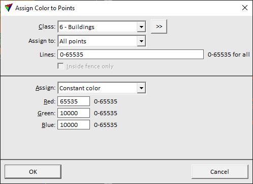
This opens the Assign Color to Points dialog:
2. Define settings and click OK.
This assigns the color to the loaded points in the selected class(es).
SETTING |
EFFECT |
|---|---|
Class |
Point class(es) effected by the color assignment. |
|
Opens the Select classes dialog which contains the list of active classes in TerraScan. You can select multiple source classes from the list that are then used in the Class field. |
Assign to |
Points to which color is assigned: •All points - all points get a new color value. •Non-colored points only - points which do not yet have a color value. |
Lines |
Determines which lines are effect by color assignment. Several line numbers can be separated by comma, line number ranges can be defined by minus, e.g. 1,4-6,29-59. Use 0-65535 to refer to all possible line numbers. |
Inside fence only |
If on, only points inside a fence or selected polygon(s) are effected by color assignment. |
Assign |
Color source: Closest colored point, Constant color, Color mixture, Distance, Group color, Intensity auto, Intensity custom or Multi scanner intensity. |
Red | Green | Blue |
RGB color values for a constant color definition. The color is defined with 16-bit values which can range from 0 to 65535. This is active only if Assign is set to Constant color. |
Attribute |
The attribute field to use as distance: •Distance - TerraScan distance attribute field. •<Extra attribute> - Extra attribute field. This is active only if Assign is set to Distance. |
Color scheme |
Location and name of a color scheme file storing intensity values. This is active only if Assign is set to Distance or From intensity. |
Mixture |
Name of the color mixture. The list contains all mixtures defined in Color mixtures category of TerraScan Settings. This is active only if Assign is set to Color mixture. |
Red scanner | Green scanner | Blue scanner |
Number of laser scanner channels. This is active only if Assign is set to Multiple scanner intensity. |
Max distance |
Maximum search radius around a point for the two closest neighbouring points from the other two scanners. This is active only if Assign is set to Multiple scanner intensity. |
Default value |
Determines the values for the two missing color channels for a point for which not enough neighbouring points from other scanners are found within the Max distance: •Minimal value - the value of 1 is used for the missing color channels. This results in a more colorful display and makes it easier to recognize features in the colored point cloud. This is recommended if colors are assigned for classification purposes. •Grey color value - the value of the single scanner is used for all channels which results in a grey color value. |
