Assign groups
Not Lite
Assign groups command assigns a group number to points of one or more classes. The grouping is done based on different methods, such as plane fitting, watershed algorithm, or 3D spacing between points.
The group assignment relies on a distance from ground value and normal vector information. Both must be computed for the points before the command is started. Use Compute distance command for loaded points or Compute distance macro action with setting Compare to = Ground in order to compute the distance value. Use Compute normal vectors command for loaded points or Compute normal vectors macro action in order to compute normal vector directions.
The group number can be used for the visualization of points and for classifying points. There are various automatic classification routines that rely on grouping. The tools from the Groups toolbox can be used to manipulate the groups manually.
The group number can be stored in TerraScan FastBinary files. Switch on the Group attribute in the Save points as dialog or in the Attributes to store dialog of a TerraScan project in order to store the group number for project block files.
To assign a group number to points:
1. Compute the distance from ground using the Compute distance command or corresponding macro action.
2. Select Assign groups command from the Group pulldown menu.
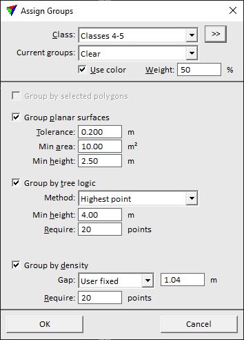
This opens the Assign Groups dialog:

2. Define settings and click OK.
This assigns a group number to points in the selected class(es) that fit the requirements. All other points get group number 0.
SETTING |
EFFECT |
|---|---|
Class |
Point class(es) included in the search for groups. |
|
Opens the Select classes dialog which contains the list of active classes in TerraScan. You can select multiple source classes from the list that are then used in the Class field. |
Current groups |
Determines how current group numbers of points are handled: •Clear - existing group numbers are deleted before assigning new numbers. •Keep - existing group numbers are kept. |
Use color |
If on, color values assigned to the points are used for grouping. The Weight of color values is determined by the given percentage value. |
Group by selected polygons |
If on, group numbers are assigned based on selected polygons. Points inside a polygon get the same group number. This is only active if one or more shape elements are selected in the CAD file. |
Group planar surfaces |
If on, points that fit to planes are grouped. Points fitting to the same plane get the same group number. |
Tolerance |
Determines how much points may differ from a plane. Point that are within the given vertical distance from a plane are grouped. This is only active if Group planar surfaces is switched on. |
Min area |
Minimum area of a planar surface for grouping points. This is only active if Group planar surfaces is switched on. |
Min height |
Minimum height above ground of a planar surface for grouping points. This is only active if Group planar surfaces is switched on. |
Group by tree logic |
If on, points on trees are grouped. Points that belong to the same tree get the same group number. |
Method |
Method of grouping trees: •Highest point - based on a watershed algorithm starting from the locally highest point. This is suitable for airborne point clouds. Thin high density point clouds before using this method for better processing time and result accuracy. •Trunk - based on approximately circular tree trunks visible in the point cloud. This requires a high amount of points from trunks and is suitable for very high-density airborne point clouds, for mobile data and point clouds from static scanners. |
Require |
Minimum number of points that form a single tree group. This is only active if Group by tree logic is switched on and Method is set to Highest point. |
Min height |
Minimum height above ground of a group. This is only active if Group by tree logic is switched on. |
Max diameter |
Maximum diameter of a tree trunk as an approximate estimate. This is only active if Group by tree logic is switched on and Method is set to Trunk. |
Min trunk |
Minimum length of the tree trunk. This is only active if Group by tree logic is switched on and Method is set to Trunk. |
Group by density |
If on, points are grouped based on their distance to each other. Close-by points get the same group number. |
Gap |
Distance between consecutive groups: •Automatic: the software decides what points belong to one group or to another. This is recommended for objects with variable gaps, such as moving objects on a road. •User fixed: the user can define a fixed distance value in the text field. This is suited for fixed objects with large distances in between, such as powerline towers. |
Require |
Minimum amount of points that form a single group. This is only active if Group by density is switched on. |
