Fit using targets
Fit using targets command can be used to georeference point clouds based on control measurements. The process derives a transformation from source and target points. In the point cloud, the following source objects are applicable:
• ball targets - ball objects with a constant and known diameter, requires empty space above the ball object, ball must be located lower than the scanner.
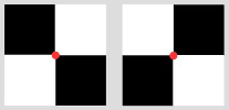
•square signals - four black and white squares in chessboard pattern, visible in the RGB colors of a point cloud and placed on vertical surfaces, such as walls.
•manual entry - interactive definition of source points.
The target points can be defined as follows:
•control points - coordinates of control points in a text file, format of the text file is PointID X Y Z.
•manual entry - interactive definition of target points.
The transformation for fitting the source points to the target points may include:
•an XYZ shift and a 2D rotation.
•a rubbersheet correction that forces the point cloud to match the control point locations with residuals to be 0. Warps the data to match the control points. The correction values are computed based on a TIN model where the modification for places outside the TIN area approach 0.
The georeferencing method is best suited for point clouds that are produced by handheld devices, static scanners or cameras (photogrammetric point clouds), SLAM data sets, also from indoor facilities.
The transformation can also be applied to trajectories that are loaded in TerraScan and linked to the point cloud loaded in TerraScan. This may be useful for SLAM data sets that include a trajectory solution in a local coordinate system. As a result, the trajectory positions are georeferenced as well.
If the difference between the original coordinate values of the point cloud and the target coordinates is very large, it may be useful to shift the point cloud to the approximate location of the geographic coordinate system before applying the Fit using targets command. This can be done by defining a linear transformation in the TerraScan Settings and applying this transformation when reading the point cloud into TerraScan. The same must be applied to trajectories, if available.
To fit a point cloud to targets:
1. Select Fit using targets command from the Line pulldown menu.
This opens the Fit Using Targets dialog:
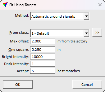
2. Define settings and click OK.
If the Method is set to an automatic target detection method, the software searches for the targets in the point cloud. It opens the Fit targets window. The window contains commands for completing the fitting task.
SETTING |
EFFECT |
|---|---|
Method |
Fitting method: •Manual entry - source and target points for computing the transformation are defined manually. No additional settings are required for this method and the Fit targets window is opened without any entries. •Automatic ball targets - ball objects are available in the point cloud and represent control point locations. •Automatic ground signals - square signal marker objects are available in the point cloud and represent control point locations. The signals must be located on horizontal surfaces and visible in intensity stored for the point cloud. •Automatic wall signals - square signal marker objects are available in the point cloud and represent control point locations. The signals must be located on vertical surfaces and visible in RGB colors stored for the point cloud. |
Ball locations |
Whether the target balls appear above or below from the scanner's perspective. This is active only if Method is set to Automatic ball targets. |
From class |
Point class in which the software searches for the target objects, such as balls or signal markers. |
To class |
Point class into which points representing the recognized target objects are classified. |
Max offset |
The maximum offset from trajectory the target search considers. This is active only if Method is set to Automatic ground signals. |
Diameter |
Diameter length of a ball target object. This is active only if Method is set to Automatic ball targets. |
One square |
Size of one square in a square signal marker. Typically, a chess-board pattern of four black and white squares forms a signal. This is the size of one black or white square. This is active only if Method is set to Automatic wall or ground signals. |
Tolerance |
For ball targets, maximum distance of points from the target objects to be considered as returns from the target object. For wall signals, maximum angle off from vertical surfaces. |
Bright/Dark intensity |
The expected intensities for bright/dark parts of the chessboard signal markers. These are active only if Method is set to Automatic ground signals. |
Require |
Minimum amount of points that are returns from a target. Only targets with at least this amount of points are considered. This is active only if Method is set to Automatic ball targets. |
Match limit |
Defines how easily the software finds a square signal based on color values. This needs to be changed if the software finds too many wrong targets or not enough correct targets in the point cloud. This is active only if Method is set to Automatic wall signals. |
Accept |
The number of targets to search. Set to the number of targets laid on the survey area during the scan. This is active only if Method is set to Automatic ground signals. |
command/button |
EFFECT |
|---|---|
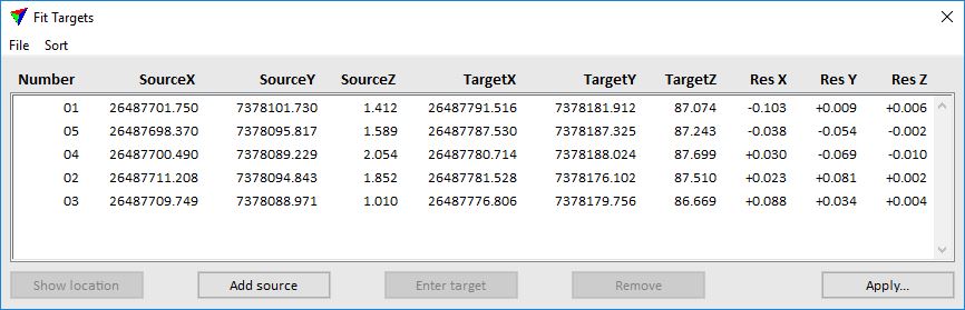
Show location |
Shows the location of a selected target object. Select an entry in the targets list and click Show location. Move the mouse pointer inside a view. The target location is highlighted by a small square and a cross. You can center the target object in the view by placing a data click inside the view. |
Add a new target object manually. Required, if Manual entry was selected as Method in the Fit Using Targets dialog or if the automatic detection of target objects fails. |
|
Define target coordinates for a target object manually. Required, if Manual entry was selected as Method in the Fit Using Targets dialog or if there are no target coordinates provided in the control point text file. |
|
Remove |
Delete a selected target object from the list and thus, from the transformation computation. Should be done for false findings of the automatic target object search before reading a control point text file. |
Apply a transformation to loaded data. |
|
Read control point coordinates from a text file and link them with the source coordinates. |
|
File / Save source xyz |
Write a text file with source point coordinates. |
File / Save transformation |
Write the transformation parameters into the Transformation category of TerraScan Settings. A transformation of Type 3D translate & rotate and with the given Name is created. |
File / Save rubbersheet |
Write the rubbersheet correction values into a text file. |
Sort |
Sort the target object list by Increasing | Decreasing X | Y. |
To add a new target object manually:
1. Create a narrow cross section of the target object in the point cloud by using the Draw vertical section tool.
2. Click Add source button in the Fit Targets window.
3. Place a data click in the cross section where you see the center point of the target object.
This adds the source coordinates of the new target object to the list in the Fit Targets window.
To enter target coordinates for a target object manually:
1. Select the target object in the list in the Fit Targets window.
2. Click Enter target button in the Fit Targets window.
3. Place a data click in any view at the target location. You may use a snapping methods to snap, for example, to the drawing of a control point in the CAD file in order to get exact XYZ coordinates.
This adds the target coordinates to the target object selected in the list.
To continue with fitting a point cloud to target objects:
3. Check the targets that are listed in the Fit Targets window. If necessary, add additional target objects or remove false findings by using the corresponding buttons of the window.
4. Select Read targets xyz command from the File pulldown menu.
This opens the Target coordinates file dialog, a standard dialog for selecting a file.
5. Select the control points text file and click Open.
The software links the control point coordinates stored in the text file with the source coordinates. Coordinates that produce the smallest residuals are linked to each other.
6. Click Apply button in the Fit Targets window.
This opens the Apply Transformation dialog:
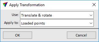
7. Define settings and click OK.
This transforms the loaded point cloud and possibly also the active trajectory files. If the transformed coordinate values exceed the active coordinate setup, TerraScan updates the settings automatically.
SETTING |
EFFECT |
|---|---|
Use |
Transformation type: •Translate & rotate - applies a translation and then a 2D rotation to the point cloud. •Translate & rotate + rubbersheet - additional rubbersheet correction. |
Apply to |
Determines which data is modified: •Loaded points - point cloud loaded in TerraScan. •Loaded points + trajectories - point cloud loaded in TerraScan, and trajectories that are in the active trajectory folder set with Manage Trajectories and linked with the loaded points. |