

TerraScan User Guide
Transform known points
Transform known points command transforms coordinate values of points in a text file. This can be used, for example, to transform known ground control points from one projection system into another.
The known point text file must be space-delimited with each row having three or four fields: (optionally) identifier, easting, northing and elevation.
The identifier field is usually a number but it may include a letter as well.
To transform a known points file:
1. Select Transform known points command from the Tools pulldown menu.
This opens the Source point file dialog, a standard dialog for selecting a file.
2. Select the file that stores the known points’ coordinates and click Open.
This opens the Transform File dialog:
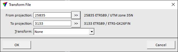
3. Define transformation settings and click OK.
This opens the Save transformed points dialog, a standard dialog for saving a file.
4. Define a storage location and name for the output file and click Save.
This saves the transformed known points into a new text file.
SETTING |
EFFECT |
|---|---|
From projection |
Projection system of the original points. Click on the >> Button to open the Browse for Projection System dialog. The dialog provides a search option for projection systems as well as a list of all implemented systems. In addition, any user-defined projection systems are included in the list. |
To projection |
Target projection system. Click on the >> Button to open the Browse for Projection System dialog. The dialog provides a search option for projection systems as well as a list of all implemented systems. In addition, any user-defined projection systems are included in the list. |
Transform |
Additional transformation applied to the points’ coordinates. The list contains all transformation defined in the Coordinate transformations / Transformations category of TerraScan Settings. |