Create Editable Model
 Create Editable Model tool creates a surface model from loaded laser points which can be visualized in TerraModeler. The tool starts TerraModeler automatically if the application is not yet running.
The surface model is actively linked to the loaded laser points, which means that all surface model displays are updated immediately to reflect any change in point classification. The active surface model display is particularly useful for validating ground classification. The best display method for this purpose is a shaded surface drawn by the Display Shaded Surface tool in TerraModeler’s Display Surface toolbox.
To create an editable model and display a shaded surface:
1. Load laser data into TerraScan.
2. Select the Create Editable Model tool.
This opens the Create editable model dialog:
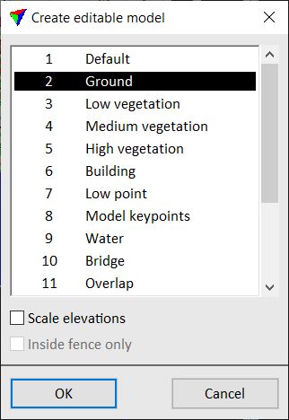
3. Select class(es) which you want to include in the surface model.
4. (Optional) Switch on Scale elevations and type a factor by which you want to scale the elevations. A factor > 1.0 results in a model with exaggerated elevation values.
5. Click OK.
This opens the Surface settings dialog in TerraModeler.
6. Enter a descriptive name for the new surface, define other settings if required, and click OK.
TerraModeler creates the surface model.
7. Select the Display Shaded Surface tool in TerraModeler’s Display Surface toolbox.
8. Define display settings and click OK.
This displays the shaded surface using the elevation values of the laser points and given lightning conditions.
If TerraModeler is not available, you can use the Color by Shading display method of TerraScan to display a shaded surface visualization of the laser points based on class coloring.