Target objects
Target objects category shows a list of target object definitions. Target objects are normally used for matching point clouds of static terrestrial laser scanners. Supported shape primitives of target objects include ball, cone and pyramid.
A target object may represent the location of a control point for which the coordinate values are known. Target objects defined in this settings category are used by the Place target object tool of the Measurement pulldown menu.
You can Add, Edit and Delete target objects by using the corresponding buttons in the Settings dialog.
To add a new target object:
1. Open the Target objects category.
2. Click Add in the Settings dialog.
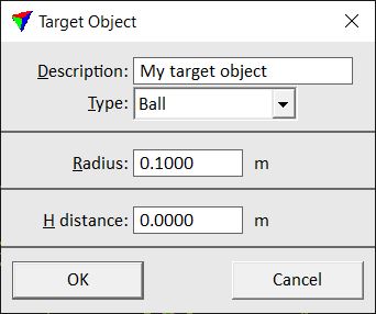
The Target Object dialog opens:
3. Define settings and click OK.
4. Close the Settings dialog in order to save the target object settings for TerraScan.
SETTING |
EFFECT |
|---|---|
Description |
Description of the target object. |
Type |
Shape primitives: Ball, Cone, or Pyramid. |
Radius |
Radius of the ball or cone. |
Depth |
Depth of a cone or pyramid. |
Width |
Width of a pyramid. |
Height |
Height of a pyramid. |
A distance |
Distance from the target object’s center point to the known control point location along the xy line from scanner to object. |
B distance |
Distance from the target object’s center point to the known control point location perpendicular to xy line from scanner to object. |
H distance |
Elevation difference from the target object’s center point to known control point location. |
Target objects are stored in a configuration file TARGETS.INF in the TerraScan installation folder. You can copy this file to other computers in order to make target object definitions available on them.