Alignment reports
Alignment reports category contains a list of alignment report formats. The formats are used by the Output alignment report command. The report format defines what information is included in the output report along an alignment element. It consists of a descriptive name and a list of columns.
To define a new alignment report format:
1. Open the Alignments reports category.
2. Click Add in the Settings dialog.
The Alignment Report Format dialog opens:
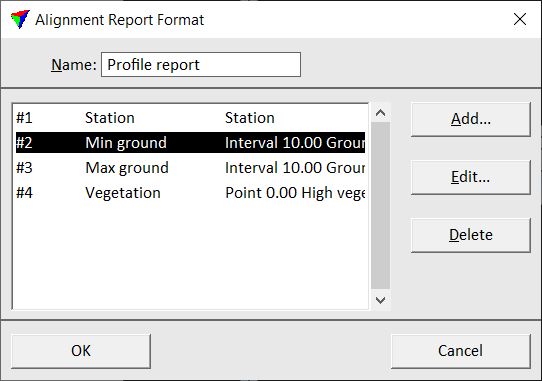
3. Type a Name for the report format.
4. Click Add in the Alignment Report Format dialog in order to add a new column definition to the report.
The Report Column dialog opens:
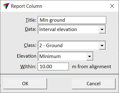
5. Define settings and click OK.
6. Repeat steps 4 and 5 for all columns you want to add to the report format.
7. Click OK in the Alignment Report Format dialog.
8. Close the Settings dialog in order to save the alignment report settings for TerraScan.
SETTING |
EFFECT |
|---|---|
Title |
Title of the report column. |
Data |
Content of the report column: •Alignment station - station value along an alignment element. •Alignment easting - easting coordinate at stations along the alignment element. •Alignment northing - northing coordinate at stations along the alignment element. •Alignment elevation - elevation coordinate at stations along the alignment element. •Interval elevation - minimum or maximum Elevation of points in a given Class. A rectangular search area is defined by the offset left and right of the alignment station given in the Within field. The interval step size along the alignment element given at report output time. •Point elevation - closest, minimum, average, or maximum Elevation value from points in a given Class inside a circular area. The center of the circular area is at the given Offset from the alignment station, the size is determined by the Radius value. •Surface elevation - elevation value of a surface model. This requires at least one active surface model in TerraModeler. The elevation value is computed from the selected Surface type at the XY location of the alignment station plus the given Offset value. •Column difference - computes the difference between two other Columns of the report. Select the number of the columns in the selection lists of the dialog. •Alert - writes an asterisk character (*) in the report if the difference between two columns is bigger or smaller than a given limit. Select the number of the columns and the comparison sign in the selection lists of the dialog. Define the limit value in the text field. |
Offset |
An offset value in the dialog refers to the distance from the alignment element. The selected Data value is determined from the location defined by the alignment station and the offset. A negative offset is left, a positive offset right of the alignment element. |
Alignment report formats are stored in a configuration file ALREPFMT.INF in the TerraScan installation folder. You can copy this file to other computers in order to make alignment report formats available on them.