Place Paint Line
 Place Paint Line tool can be used for the digitization of paint lines along a road. The tool supports the manual placement of shapes for dashed or continues paint lines in the center or along edges of roads. It can be used to place straight lines but also to digitize line strings similar to the Place railroad string tool.
Alternatively, the tool can also be used to convert selected line elements into polygon elements.
To place a paint line drawing manually:
1. Select the Place Paint Line tool.
The Place Paint Line dialog opens:
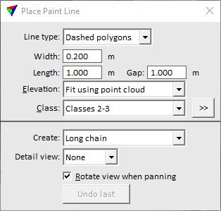
2. Define settings.
3. Start the digitization at one end point of a paint line with a data click.
The shape of the paint line is displayed dynamically from the given location to the mouse pointer position.
If Create is set to Long chain, the application draws a dynamic rectangle whenever you start the digitization of a line string. If you place a data click outside the rectangle, the application pans the view in the direction of the data click. If Rotate view when panning is switched on, the view is also rotated in the direction of the data click. If you place a data click inside the rectangle, you add a new vertex to the line string.
4. Place another data click to define the next point of the paint line.
If Create is set to Short line, this finishes the paint line drawing.
If Create is set to Long chain, this defines an intermediate vertex of a line string. You can continue with step 4. Place a reset click in order to end a paint line drawing.
This creates individual shape elements for each paint line (dash). You can modify the shapes using CAD tools.
SETTING |
EFFECT |
|---|---|
Line type |
Defines the type of a paint line drawing: •Centerline - line or line string element. •Continuous polygon - one polygon element. •Dashed polygons - one or more polygons forming a dashed line. |
Width |
Width of the paint line. This is active only if Line Type is set to Continuous polygon or Dashed polygons. |
Length |
Length of a paint line dash. This is active only if Line Type is set to Dashed polygons. |
Gap |
Distance between paint line dashes. This is active only if Line Type is set to Dashed polygons. |
Elevation |
Determines how the Z value for the crosswalk drawing is defined: •Mouse click - the current mouse pointer elevation is used. This results in a 2D-like drawing. •Fit using point cloud - a single plane equation is used to fit the crosswalk drawing to the point cloud. This results in a 3D-like drawing. •<surface model> - a single plane equation is used to fit the crosswalk drawing to a surface model loaded in TerraModeler. This results in a 3D-like drawing. |
Class |
Point class(es) from which to derive the elevation of the drawing. This is active only if Elevation is set to Fit using point cloud. |
|
Opens the Select classes dialog which contains the list of active classes in TerraScan. You can select multiple source classes from the list that are then used in the Class field. |
Create |
Line type to create: •Short line - a straight line defined by two end points. •Long chain - a line string that may contain intermediate vertices. |
Detail view |
An optional view which is synchronized with the view used for placing the mouse clicks. This is active only if Create is set to Long chain. |
Rotate view when panning |
If on, the view is rotated in the direction of the data click. This is active only if Create is set to Long chain. |
Undo last |
Deletes the last vertex that was placed. The undo action can be applied several times. This is active only if Create is set to Long chain. |

To convert a line string into a polygon drawing:
1. Select line string element(s).
2. Select the Place Paint Line tool.
The Place Paint Line dialog opens:
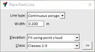
3. Define settings.
4. Place a data click inside a CAD view in order to confirm the conversion.
This creates polygon elements from all selected line elements. The original line elements are kept in the CAD file.