By vegetation index
Not Lite
By vegetation index routine classifies points based on a vegetation index computation. The routine requires that color values have been extracted for the points. Color values for laser points can be extracted from raw images or raster attachments loaded into TerraPhoto, or assigned per class by setting values for red, green, and blue channels. See Extract color from images and Assign color to points for corresponding commands in TerraScan.
TerraScan can assign up to 10 color channels for each point. The maximum amount of color channels can only be stored in the TerraScan FastBinary format. LAS 1.4 format and later can store up to 4 color channels, LAS 1.2 format and later up to 3.
There are two implemented methods for computing the vegetation index.
Normalized difference
The method assumes that channel 0 stores red (R) and channel 3 near-infrared (NIR) color values. The normalized difference value is computed with the following equation:
ND = (NIR - R) / (NIR + R) -1 <= ND <= +1
Visual band difference
The method assumes that channel 0 stores red (R), channel 1 green (G), and channel 2 blue (B) color values. The visual band difference value is computed with the following equation:
VBD = (2*G - R - B) / (2*G + R + B) -1 <= VBD <= +1
The routine is well suited for separating points on vegetation from non-vegetation points. You can check how well the vegetation index computation separates vegetation from non-vegetation points by displaying points by vegetation index. The larger the difference value, the more likely a point is representing vegetation.
In addition to the implemented methods, there may be User vegetation indexes defined in the corresponding category of TerraScan Settings.
SETTING |
EFFECT |
|---|---|
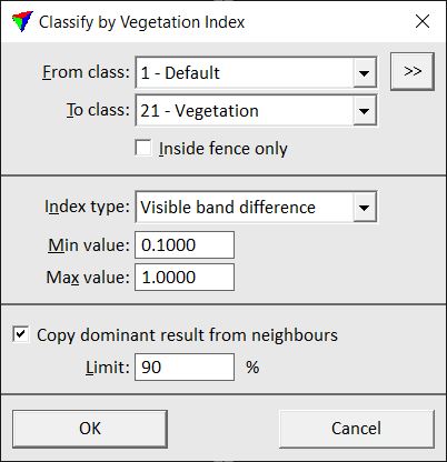
From class |
Source class(es). |
|
Opens the Select classes dialog which contains the list of active classes in TerraScan. You can select multiple source classes from the list that are then used in the From class field. |
To class |
Target class. |
Inside fence only |
If on, points inside a fence or selected polygon(s) are classified. |
Index type |
Method of vegetation index computation: Normalized difference, Visual band difference, or any User vegetation index defined in TerraScan Settings. |
Min value |
Minimum difference value to be classified. |
Max value |
Maximum difference value to be classified. |
Copy dominant result from neighbours |
If on, the software checks neighbouring points before classifying a point. If the percentage of neighbouring points given in the Limit field are classified, the point is classified as well. This avoids that single isolated points are classified as vegetation or non-vegetation. |
