Search tie lines
Search tie lines command opens the Search tie lines dialog from which the automatic tie line search can be started. With the automatic tie line search you can search for tie lines of various types.
The automatic tie line search can be based either on laser points loaded into TerraScan or on a TerraScan project. Tie line search can also run as macro action in TerraScan. In this case, a settings file has to be stored from the Search tie lines dialog.
The different tie line types are searched for in different laser point classes depending on the settings in the Define Tie Lines dialog:
•Vertical walls - wall classes
•Group objects - object classes
•Paint lines - ground classes
•Planar points - ground classes
•Flat ground - ground classes
•Surface lines - ground classes
•Roof intersections - roof classes
•Paint line corners - ground classes
The tie line settings can be changed between several tie line searches using the Settings command from the View pulldown menu. When searching first for one tie line type and then for another, the new tie lines are added to the active tie lines at the end of the tie line list.
To search tie lines:
1. Select Search tie lines command from the File pulldown menu.
This opens the Search tie lines dialog:
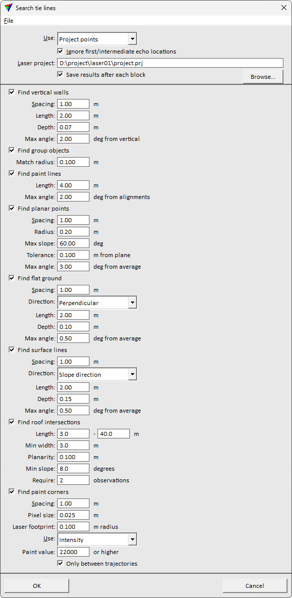
2. Define settings and click OK.
The software starts the search for tie lines. As a result, tie lines of the selected type are added to the list of active tie lines. The amount of tie lines found is displayed in an information dialog after the search is completed.
Setting |
Effect |
|---|---|
Use |
Laser points used for placing the tie lines: Project points (not UAV) or Loaded points . |
Ignore first/intermediate echo locations |
If on, locations where there are laser points of first or intermediate echo types are ignored. |
Laser project |
Path to a TerraScan project. This is only active if Use is set to Project points. |
Save results after each block |
If on, the tie lines are saved automatically into a file after the search is completed for a block of a project. This is only active if Use is set to Project points. |
Find vertical walls |
Search for tie lines on vertical walls or structures within the Wall classes defined in the settings. •Spacing - distance between two tie line locations. The value determines the maximum density of the tie lines. •Length - length of a tie line. •Depth - depth of a section where the software tries to fit the tie line to the laser points. •Max angle - maximum allowed angle off from vertical for a tie line placed on a vertical structure. |
Find group objects |
Search for tie lines based on groups of points that represent a certain object type. Objects are defined by classified and grouped points in TerraScan. Each object must be assigned to one group and groups of one object type must be classified into a separate class. •Match radius - maximum distance between a point in the object group in one line and the closest point in the object group in another line. |
Find paint lines |
Search for tie lines on bright paint markings using a selected vector of known points along the center of paint marking. •Length - length of a tie line. •Max angle - maximum allowed angle off from average between the tie lines at the same location. |
Find planar points |
Search for tie lines on planar surfaces within the Ground classes defined in the settings. •Spacing - distance between two tie line locations. The value determines the maximum density of the tie lines. •Radius - size for point sampling footprint in local plane extraction. •Max slope - maximum allowed angle off from horizontal for a plane fit. •Tolerance - distance tolerance between points and plane equation for outlier filtering. •Max angle - maximum allowed angle off from average between the tie lines at the same location. |
Find flat ground |
Search for tie lines on flat ground or horizontal surfaces within the Ground classes defined in the settings. •Spacing - distance between two tie line locations. The value determines the maximum density of the tie lines. •Direction - direction of a tie line relative to the movement direction: Along movement or Perpendicular. •Length - length of a tie line. •Depth - depth of a section where the software tries to fit the tie line to the laser points. •Max angle - maximum allowed angle off from average between the tie lines at the same location. |
Find surface lines |
Search for tie lines on surfaces within the Ground classes defined in the settings. •Spacing - distance between two tie line locations. The value determines the maximum density of the tie lines. •Direction - direction of a tie line relative to the movement direction or terrain slope: Along movement, Perpendicular, or Slope direction. •Length - length of a tie line. •Depth - depth of a section where the software tries to fit the tie line to the laser points. •Max angle - maximum allowed angle off from average between the tie lines at the same location. |
Find roof intersection lines |
Search for tie lines along intersections of roof planes within the Roof classes defined in the settings. •Length - length range of a tie line. •Min width - minimum width of the roof planes on both sides of the tie line. •Planarity - distance tolerance between point and plane equation of the planar roof patch it belongs to. •Min slope - minimum slope off from horizontal of the roof planes. •Require - number of observations required for accepting a tie line location. Minimum is 2 observations (from 2 strips). |
Find paint corners |
Search for tie lines based on intensity (alternatively reflectance or amplitude) values in MLS point clouds. The software tries to identify corners of paint markings on the road surface. This requires good intensity values. If there are systematic issues with intensity values (such as weeker intensity for points at a longer distance from scanner or smaller angle of incidence), an intensity correction may be required, e.g. with the Find intensity correction tool of TerraMatch. •Spacing - distance between two tie line locations. The value determines the maximum density of the tie lines. •Pixel size - pixel size of the intensity raster that is internally created from each drive path. Use a smaller size than the scan line distance in the point cloud. •Laser footprint - for each pixel in the intensity raster, a circular area of the given radius is used to compute a distance-weighted average intensity value from the laser points. •Use - point attribute used for placing the tie lines. Alternatives for the Intensity attribute are the Reflectance or Amplitude attributes (e.g. from Riegl Extra Bytes). •Paint value - intensity values that represent bright paint markings in a point cloud. The minimum value is given in the text field. This needs to be tested for each point cloud, e.g. with the TerraScan option to classify points by intensity. •Only between trajectories - if on, the search for tie lines is reduced to the area between trajectories which corresponds to the road center area. |
Load settings command can be used to open a previously stored settings file.
To open a tie line search settings file:
1. Select Load settings command from the File pulldown menu.
This opens the Tie line settings file dialog, a standard Windows dialog for opening files.
3. Select a settings file and click Open.
Save settings command lets you save tie line search settings into a file. The file can be used by the TerraScan macro action for searching tie lines. The file can also be loaded into TerraMatch using the Load settings command from the Search tie lines dialog. The settings are stored into a text file with the extension .SET. The settings file includes settings from the Seach tie lines dialog as well as settings from the Define tie lines dialog.
To save a tie line search settings file:
1. Define settings for the tie line search in the Search tie lines dialog.
2. Select Save settings command from the File pulldown menu.
This opens the Tie line settings file dialog, a standard Windows dialog for saving files.
3. Define a location and name for the settings file and click Save.