Convert Raster Files
 Convert Raster Files tool converts raster files from one image format to another. The tool can also be used to adjust the brightness of images, to transform the positions of images, to modify the background color, or to change the image orientation between landscape and portrait.
To convert raster files:
1. Select the Convert Raster Files tool.
This opens the Source files dialog, a standard dialog for selecting files.
2. Add the raster file(s) to the list of files to process and click Done.
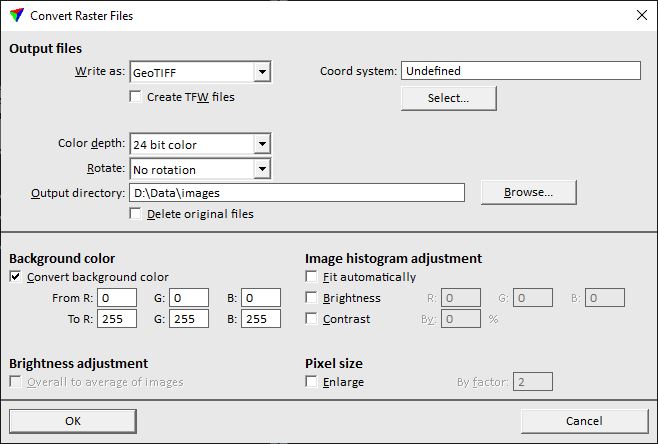
This opens the Convert Raster Files dialog:
3. Define settings and click OK.
This converts the images and creates new files in the Output directory. A progress bar shows the progress of the process.
SETTING |
EFFECT |
|---|---|
Write as |
Format of the output files. Supported file formats include: BMP, ECW compressed, GeoTIFF, JPEG, JPEG2000, Raw RGB, and TIFF. Some of the following settings depend on the selected format. |
Target ratio |
Compression ratio for ECW or JPEG2000 files. |
Datum |
Datum information that is written in the header of ECW and JPEG2000 files. Commonly used datum names can be selected by using the Select button. |
Projection |
Projection information that is written in the header of ECW and JPEG2000 files. Commonly used projection names can be selected by using the Select button. |
Create TFW|JGW file |
If on, external georeference files are created for GeoTIFF and JPEG files. The files have the extension .TFW|.JGW. |
Coord system |
Coordinate system information that is written in the header of GeoTIFF files. Commonly used coordinate system names and numbers can be selected by using the Select button. |
Coordinates |
Coordinate transformation to apply to image positions. The transformation can result in translation of position and scaling of pixel size but no rotation is supported. The list contains transformations that are defined in Coordinate transformations / Transformations category of TerraPhoto Settings. |
Color depth |
Defines how color values are stored in the output file: 24 bit color or Grey scale. |
Rotate |
Rotation applied to converted raster files: •Clockwise - 90 degree clockwise. •Counter clockwise - 90 degree counter clockwise. •180 degrees - 180 degree. •Clockwise to landscape - 90 degree clockwise if the source image has portrait orientation. •Counter clockwise to landscape - 90 degree counter clockwise if the source image has portrait orientation. |
Output directory |
Directory into which the converted images are stored. |
Delete original files |
If on, the original raster files are deleted after conversion. |
Convert background color |
If on, the background color is changed From RGB values To RGB values. |
Overall to average of images |
If on, the application computes the average brightness of all source images and adjust each converted image to that average brightness. |
Fit automatically |
If on, the histogram of each image is fitted automatically. |
Brightness |
If on, the brightness of each image is modified by adding the given values in the RGB fields to the red, green, and blue color components separately. |
Contrast |
If on, the contrast of each image is modified by adding the given percentage value in the By field. |
Enlarge |
If on, the resolution of the converted images is reduced by merging source image pixels into larger pixels. The value given in the By factor field determines how many pixels are merged horizontally and vertically. |