Coordinate transformations / User projection systems
User projection systems category in Coordinate transformations folder contains a list of user defined projection systems. You can define your projection system based on Transverse Mercator / Gauss-Krueger, Lambert conic conformal or Hotine oblique mercator projection.
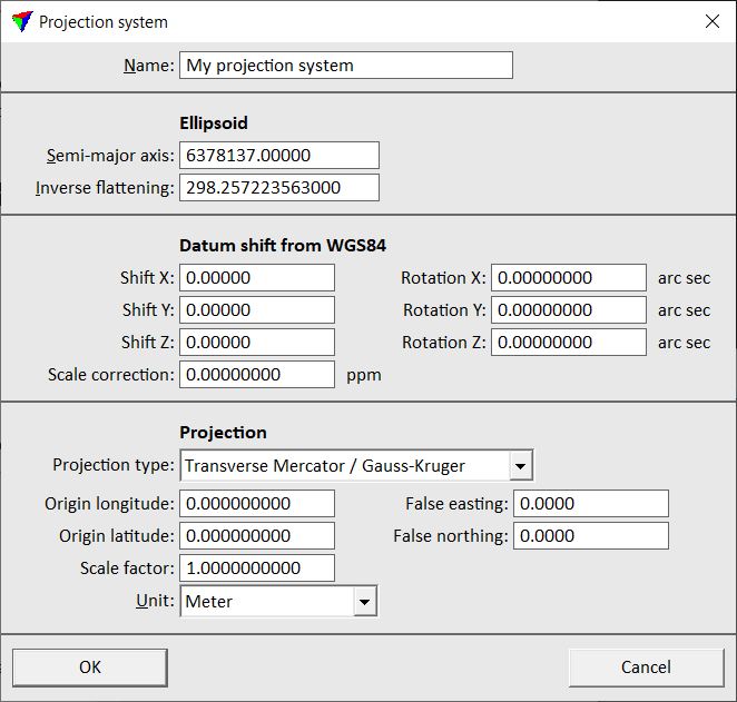
A projection system definition can be divided into three distinct parts:
•Ellipsoid - defined by Semi-major axis and Inverse flattening.
•Datum - defined by seven parameter Bursa/Wolfe transformation.
•Projection - defined by the projection type, true origin, false origin, scale factor at the central meridian, and distance unit.
The list of user projection system displays a toggle box for each row. The toggle box indicates whether a projection system is active or not. Only active projection systems can be selected when applying a transformation. To activate or deactivate a projection system, place a data click inside its toggle box in the list.
You can Add, Edit, and Delete user projection systems by using the corresponding buttons in the Settings dialog. The Copy button copies the selected projections system definition to the clipboard. With the Paste button you can paste a projection system definition from the clipboard.
To define a new projection system:
1. Open the User projection systems category in the Coordinate transformations folder.
2. Click Add in the Settings dialog.
This opens the Projection system dialog:
3. Define settings and click OK.
4. Activate the projection system.
5. Close the Settings dialog in order to save the modified settings for TerraScan.
SETTING |
EFFECT |
|---|---|
Name |
Descriptive name for the projection system. |
Semi-major axis |
Semi-major axis of the target ellipsoid. |
Inverse flattening |
Inverse flattening of the target ellipsoid. |
Shift X |
Datum X shift from WGS84 to the target system in meter. |
Shift Y |
Datum Y shift from WGS84 to the target system in meter. |
Shift Z |
Datum Z shift from WGS84 to the target system in meter. |
Rotation X |
Datum rotation around the X axis in arc seconds. |
Rotation Y |
Datum rotation around the Y axis in arc seconds. |
Rotation Z |
Datum rotation around the Z axis in arc seconds. |
Scale correction |
Datum scale correction as parts per million. The actual scale factor is computed as 1.0 + (0.000001 * ScaleFactor). |
Projection type |
Type of the projection system: Transverse Mercator/Gauss-Kruger, Lambert conic conformal 1SP | 2SP, Hotine oblique mercator A | B, Swiss conic conformal. |
Origin longitude |
Longitude of the true origin in decimal degrees. |
Origin latitude |
Latitude of the true origin in decimal degrees. |
False easting |
Map coordinate easting of the true origin. |
False northing |
Map coordinate northing of the true origin. |
Scale factor |
Scale factor on the central meridian. |
Unit |
Distance unit: Meter, International foot, US Survey Foot, or International yard. |
You can copy user projection systems from one Terra application to another. Select the system in the Settings dialog and click on the Copy button to copy the definition to the clipboard. Click on the Paste button in the other Terra application to paste the definition. You can also paste the definition in a text editor in order to save it into a text file.