Remove Vegetation
 Remove Vegetation tool removes points in vegetation from points classified as ground. It works within a limited area defined by a selected polygon or a fence.
The can be used, for example, to smooth the ground surface after automatic ground classification.
To remove vegetation from ground points:
1. Use CAD tools to draw a polygon or fence around the area for processing. Select the polygon.
2. Select the Remove Vegetation tool.
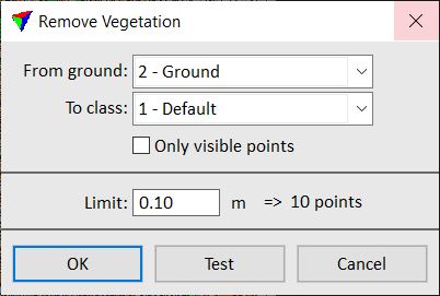
The Remove Vegetation dialog opens:
3. Define settings.
4. Click on the Test button to see the result of the settings in a preview.
5. Click OK to apply the classification.
This classifies the points from the ground class to the target class.
6. Use Save points or Save points As commands in order to save changes to point classes permanently into a laser point file.
SETTING |
EFFECT |
|---|---|
From ground |
Source class, usually a ground class; only points from the selected class is effected. The list contains the active classes in TerraScan. |
To class |
Target class into which points are classified. The list contains the active classes in TerraScan. |
Only visible points |
If on, only points that are visible in the marked processing area are effected. If off, all points in the marked processing area are effected, even if their display is switched off. |
Limit |
Distance up to which points above a surface defined by the lowest ground points are classified. Given in the master unit of the CAD file. The amount of effected points is shown next to the input field. |