Export lattice models
Not UAV
Export lattice models command creates grid files with uniform distances between points from one or more selected laser point classes. For each grid point, the lattice model file stores XY coordinates and one of the following value types:
•elevation values
•point count/density values
•distance values computed for points with the Compute distance command or corresponding macro action
•analytical values, such as average intensity, horizontal or vertical distance, surface roughness
There are several formats supported to store lattice models as raster or text files. The command requires the selection of at least one polygon that defines the lattice model boundary. If several polygons are selected, the software creates a separate lattice model file for each polygon. Text elements placed inside the polygon(s) can be used as file names for the lattice model files. A polygonal area is always expanded to a rectangular area of a lattice model. The cells outside the polygon are filled with a defined “outside” value or can be skipped from output in XYZ text files.
To export a lattice model:
1. Draw rectangle(s) around area(s) from which you want to create lattice model(s). (Optional) Place text elements inside the rectangles. Select rectangle(s) and (optional) text(s).
2. Select Export lattice model command from the Tools pulldown menu.
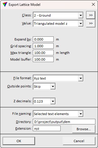
This opens the Export Lattice Model dialog:
3. Define settings and click OK.
This starts the lattice model file creation.
If File naming is set to Enter name for each, the Export lattice model dialog opens, a standard dialog for saving files.
4. Define a location and name for the lattice file and click Save.
Repeat step 4 for each lattice model.
SETTING |
EFFECT |
Class |
Source class(es) for lattice model creation. |
|
Opens the Select classes dialog which contains the list of active classes in TerraScan. You can select multiple source classes from the list that are then used in the Class field. |
Value |
Value stored for each grid point of a lattice model: •Triangulated model z - elevation value calculated from a TIN model of the points in the source class(es). •Highest hit z - elevation value determined by the highest point in the source class(es). •Average hit z - elevation value calculated as average of points in the source class(es) falling inside the grid cell. •Lowest hit z - elevation value determined by the lowest point in the source class(es). •Closest hit z - elevation value determined by the point closest to the grid cell center in the source class(es). •Point count - amount of points falling inside the cell. •Point density - amount of points per squared master unit. •Average intensity - average intensity value of points in the source class(es) falling inside the grid cell. •Distance to point - average horizontal distance between a grid point and the two closest points in the source class(es). •Dz from ground - vertical distance between a grid point and a surface model created from the Ground class(es). •Surface roughness - difference of a grid point from a plane fitted to the closest points in the source class(es). Represents the local elevation variation of points in the source class(es). •Biggest distance - biggest distance value inside the grid cell. Requires that a distance value is computed for each point using the command for loaded points or corresponding macro action. •Average distance - average distance value of points inside the grid cell. Requires that a distance value is computed for each point using the command for loaded points or corresponding macro action. •Smallest distance - smallest distance value inside the grid cell. Requires that a distance value is computed for each point using the command for loaded points or corresponding macro action. |
Ground |
Source class(es) for creating a surface model. This is only active if Value is set to Dz from ground. |
|
Opens the Select classes dialog which contains the list of active classes in TerraScan. You can select multiple source classes from the list that are then used in the Ground field. |
Expand by |
Distance by which a selected polygon is expanded for the model export. The area covered by the expanded polygon is included in a lattice model file. |
Grid spacing |
Defines the distance between grid points and thus, the resolution of the lattice model. |
Max triangle |
Maximum length of a triangle edge for TIN creation. Effects how big gaps are filled in the lattice model by interpolating grid point values from the TIN. This is only active if Value is set to Triangulated model z or Distance to point. |
Model buffer |
Width of a buffer area around the actual model area that is considered for calculating grid point values. This is only active if Value is set to Triangulated model z, Distance to point, Dz from ground, or Surface roughness. |
Fill gaps up to |
Defines the size of gaps that are filled in the lattice model by deriving grid point values from closest points in the source class(es). This is only active if Value is set to Highest|Average| Lowest hit z, Average intensity, or Surface roughness. |
Conserve memory |
If on, the software first determines how many points will be loaded and thus, how much memory needs to be allocated for the exact number of points. This slows down the process but it is less likely to run out of memory. |
File format |
Format of the lattice model file: ArcInfo, GeoTIFF, Intergraph GRD, Raw, Surfer ASCII or binary, Xyz text. |
Z unit |
Unit of grid point values. Relevant for formats storing elevations as integers. This is only active if File format is set to GeoTIFF, Intergraph GRD, or Raw. |
Outside points |
Defines how the software handles grid cells that are not covered by points in the source class(es): Skip or Output. This is only active if File format is set to Xyz text. |
Outside Z |
Defines the value for grid cells that are inside the rectangular lattice model area but not covered by points in the source class(es). This is only active if File format is set to ArcInfo, GeoTIFF, Surfer ASCII and binary, Xyz text. |
Z decimals |
Determines the number of decimals stored for the grid point value. This is only active if File format is set to ArcInfo, Surfer ASCII, or Xyz text. |
Create TFW files |
If on, the software creates external georeference files for GeoTIFFs. This is only active if File format is set to GeoTIFF. |
File naming |
Defines how lattice model files are named: •Enter name for each - a name for each lattice model file has to be defined manually. •Selected text elements - selected text elements inside the lattice model area are used as file names. |
Directory |
Directory for storing lattice model files. Click on the Browse button in order to select a folder in the Browse For Folder dialog. This is only active if File naming is set to Selected text elements. |
Extension |
Extension of lattice model files. There may be a specific extension required for a certain file format, such as .GRD for ArcInfo or .TIF for GeoTIFF. This is only active if File naming is set to Selected text elements. |

Lattice models can be produced by using •Export lattice models command for loaded points. •Export lattice macro action. •Produce lattice models command in TerraModeler |