Smoothen points
Smoothen points command can be used to smooth attributes of laser points. The points are modified according to their closest neighbours. This results in a more homogeneous appearance of the point cloud. The following methods can be applied:
•Xyz aggressive - 3D smoothing process similar to Xyz surface, but more aggressive. May result in loss of detail, so should be primarily applied on selected areas only, where the points are known to represent a smooth surface.
•Xyz corn row - 3D smoothing process applying smoothing over scan lines to mitigate corn row effect.
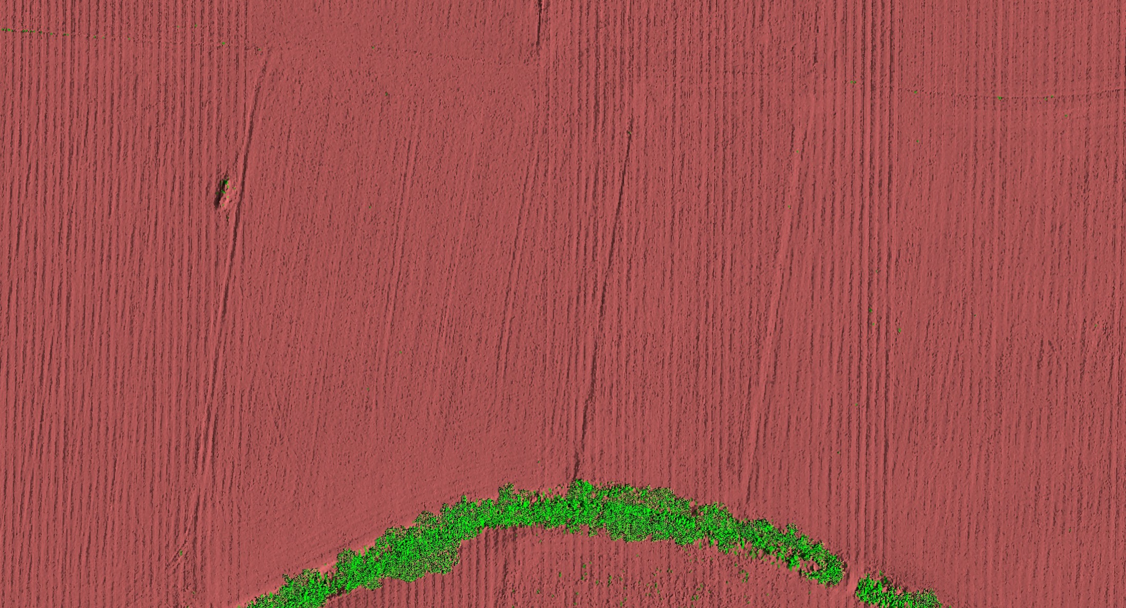
Typical Corn row -effect. Elevation of scan lines fluctuates along the travel direction. |
•Xyz surface - 3D smoothing process, 25-30 neighboring points are used to fit a 2nd degree surface, points are moved in XYZ closer to this fitted surface, points on vertical surfaces are smoothed in XY direction, point on horizontal surfaces in Z direction.
•Xyz wires - smoothing process dedicated to linear features, points are moved closer to a locally fitted line.
•Elevation - adjusts elevation values of laser points iteratively. A best fit plane equation is derived for this group of points and the elevation of the center point is adjusted to better match the plane equation. Then, the application tries to decide what areas became smooth and what areas did not result in a smooth surface. Only the smooth areas are finally adjusted. Areas which still have significant elevation variation are restored to the original state.
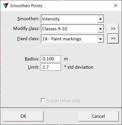
•Intensity - averages intensity values of each point with its closest neighbors.
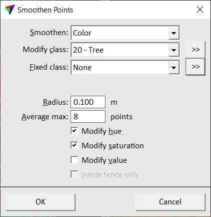
•Color - averages color values of each point with its closest neighbors.
•Distance - averages distance value of each point with a given amount of neighbor points. This may be useful to reduce the noise of vegetation index values derived from color information. Thus, the result represents more the real vegetation pattern of an area with less noise. This may also improve the classification of ground in photogrammetric point clouds, as it can be supported by the distance value.
You would normally run elevation smoothing on ground point class in order to:
•remove random variation in laser point elevations and produce a more accurate model.
•produce a smoother surface so that contours look nicer.
•produce a smoother surface so that profile drawings look nicer.
You should not use elevation smoothing if:
•the terrain is covered with low vegetation and there are no smooth surfaces.
•you intend to extract features which have only a small elevation change such as road curb stone lines. Those would be completely smoothed out.
You can include a point class into the smoothing process which is used in the smoothing process but not modified. You can use this capability, for example, if you have classified points close to breakline features into a separate class (elevation smoothing) or if points on paint markings are classified into a separate class (intensity smoothing for points on road surfaces).
To smoothen points:
1. Select Smoothen points command from the Tools pulldown menu.
This opens the Smoothen Points dialog:
|
|
|
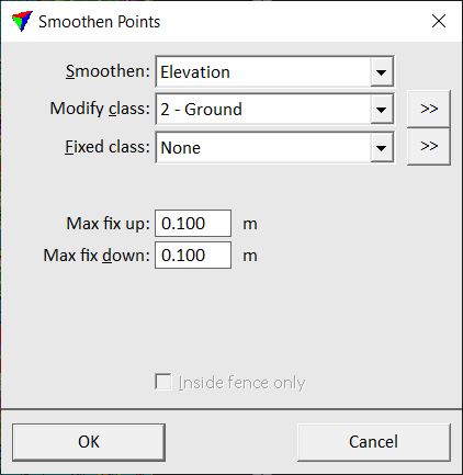
2. Define values and click OK.
This starts smoothing process.
SETTING |
EFFECT |
|---|---|
Smoothen |
Smoothing method: Xyz - aggressive, Xyz - corn row, Xyz - surface, Xyz - wires, Elevation, Intensity, Color or Distance values. |
Modify class |
Point class(es) included in and modified by the smoothing process. |
|
Opens the Select classes dialog which contains the list of active classes in TerraScan. You can select multiple source classes from the list that are then used in the Modify class field. |
Fixed class |
Point class(es) included in the smoothing process but points in these classes are not modified. |
|
Opens the Select classes dialog which contains the list of active classes in TerraScan. You can select multiple source classes from the list that are then used in the Fixed class field. |
Fit line |
The size of the neighborhood considered in adjustment extraction. Bigger value involves more points to the process, slowing it down, but successful adjustment requires some redundancy. This is only active if Smoothen is set to Xyz - corn row. |
Max fix | up | down |
Maximum horizontal/vertical up/down change to apply to a point. A point is not modified if it is more than the given value away form a locally fitted plane or line. This is only active if Smoothen is set to Xyz - surface, Xyz - wires or Elevation. |
Averaging |
Method for averaging the smoothing magnitude when Smoothen is set to Xyz - corn row. •By scan line - average smoothing magnitude over single scan lines. Use this option with quickly fluctuating noise making the row pattern irregular. •By angle range - average the smoothing magnitude over several scan lines within scan angle range. Use this option if the row pattern is visible. |
Angle range |
Mirror angle range to use for smoothing the adjustment. Use smaller value to make smoothing more aggressive. This is only active if Smoothen is set to Xyz - corn row. |
Use reliability as weight factor |
If on, the reliability value stored for points is considered when smoothing points. This is only active if Smoothen is set to Xyz. |
Radius |
3D distance from a point which defines the sample area for line or surface fitting or from which the average color, intensity or distance value is derived. This is only active if Smoothen is set to Xyz - aggressive, Xyz - wires, Intensity, Color or Distance. |
Limit |
Defines the maximum intensity value of points that are effected by the smoothing process. Given as factor of the standard deviation of intensity values in the sample area defined by the Radius. If a point differs more in intensity from its neighbours than the computed limit, it is not effected by the smoothing process.This is only active if Smoothen is set to Intensity. |
Average max |
Maximum amount of points that are included in the average distance computation. This is only active if Smoothen is set to Distance. |
Separate scanners |
If on, adjustment magnitude is derived considering points from each scanner separately. This is only active if Smoothen is set to Xyz - corn row. |
Modify hue |
If on, the hue component of the HSV value of a point is modified. This is only active if Smoothen is set to Color. |
Modify saturation |
If on, the saturation component of the HSV value of a point is modified. This is only active if Smoothen is set to Color. |
Modify value |
If on, the value component of the HSV value of a point is modified. This is only active if Smoothen is set to Color. |
Inside fence only |
If on, only points inside a fence or selected polygon are effected by the process. Requires a fence or a selected polygon in the CAD file. |
