Detect trees
Not Lite, Limited in Spatix
Detect trees command detects trees from the laser point cloud automatically based on tree shape definitions. This requires the classification of the laser points into ground, vegetation and optionally building points as well as the definition of tree types in TerraScan Settings. See Tree types category for information on how to define tree types.
For detected trees, either Bentley cells or RPC cells can be placed to represent trees in 3D visualizations. Bentley cells must be defined in the Bentley Cell Library to be placed correctly. RPC cells are replaced by RPC files when a view is rendered and if the software finds the RPC file at the given location. Settings for cell names and RPC files can be found in the Tree types category of TerraScan Settings as well.
RPC files are purchased by Archvision (www.archvision.com). For more information about RPC cells and visualization options, see TerraPhoto User Guide or the Bentley Online Help.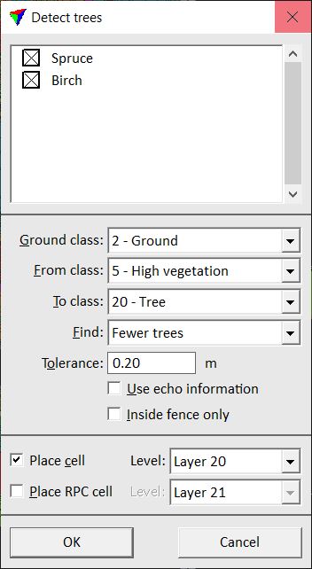
The automatic tree detection is based on tree crown shapes that it tries to detect in the point cloud. It is possible to distinguish trees with clearly different crown shapes, such as very slim shapes of many coniferous trees from very round shapes of some deciduous trees. The tool is not able to detect different tree types or the true amount of trees in tree groups or a dense forest. Thus, the aim of the tree detection is mainly visualization for which the real amount of trees in tree groups or forests does not play a role.
To detect trees from laser points:
1. Select Detect trees command from the Classify pulldown menu.
This opens the Detect trees dialog.
2. Select one or more tree types listed in the upper part of the dialog.
3. Define settings for tree detection.
4. Click OK.
The software starts the detection process. It classifies points from detected trees into the given target class and (optionally) places cells and/or RPC cells on each tree location. A process window shows the progress of the detection. Depending on the amount of ground and vegetation points loaded into TerraScan and given settings, the process might take some time.
SETTING |
EFFECT |
|---|---|
Ground class |
Point class representing the ground level. |
From class |
Source point class from which trees are detected. |
To class |
Target point class for points from detected trees. |
Find |
Determines how many trees are detected: •More trees - higher amount of trees is detected. •Normal level - normal amount of trees is detected. •Fewer trees - lower amount of trees is detected. |
Tolerance |
Positional accuracy tolerance for laser points. |
Use echo information |
If on, echo information is used for determining what is likely to be a tree. |
Inside fence only |
If on, the detection area is limited to a fence area. Requires that a fence is drawn or a polygon is selected in the CAD file. |
Place cell |
If on, Bentley cells are places at detected tree locations. |
Place RPC cells |
If on, RPC cells are placed at detected tree locations. |
RPC cells can be also placed manually based on laser points and aerial images using the Place Rpc Tree tool in TerraPhoto.
At the moment, cells and thus, the cell placement options of the Detect trees tool only works in Bentley. There is not yet any corresponding element type in Spatix.