Compare with reference
Compare with reference command compares two laser data sets from the same location. It classifies locations where the two data sets differ from each other. This is useful to locate places where buildings or other objects have been built or destroyed, trees have grown or ground has changed.
The command can be used for simple change detection analysis based in loaded points. The newer data set is loaded as active point cloud. The older data set is loaded as reference points. Alternatively, the newer data set is stored in the active project, the older data set has to be defined as a reference project. See New project for information about defining a reference project.
The process can distinguish between ground and object comparison. Ground comparison is based on a triangulated ground surface calculated from the given classes in the active and the reference laser points. For object comparison, a search radius is defined around each active point within which the software expects a corresponding reference point on the same object.
It is required that different classes are set for ground and object comparison, even if no classification is applied for one or the other comparison. However, the same class numbers can be used in active and reference projects.
To compare laser points with a reference project:
1. Select Read point command from the File pulldown menu in order to load the active point cloud. Select Read reference points from File pulldown menu in order to load the reference point cloud.
OR
1. Select Open block command from the File pulldown menu. In the Open Block dialog, switch on the Load reference points option.
2. Select Compare with reference command from the Tools pulldown menu.
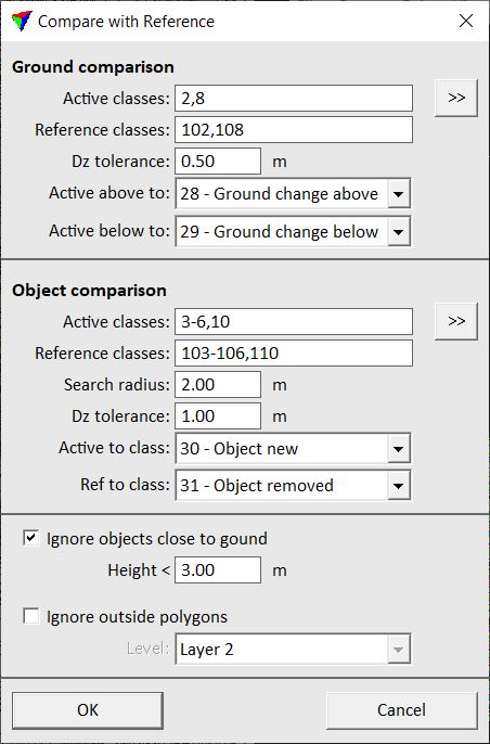
This opens the Compare with Reference dialog:
3. Define settings and click OK.
This classifies points for which there are no corresponding points in the other project.
SETTING |
EFFECT |
|---|---|
Active classes |
List of classes for ground comparison in active laser points. |
|
Opens the Select classes dialog which contains the list of active classes in TerraScan. You can select multiple source classes from the list that are then used in the Active classes field. |
Reference classes |
List of classes for ground comparison in reference laser points. |
Dz tolerance |
Elevation tolerance for ground comparison. Points within this tolerance are considered as corresponding points. |
Active above to |
Points in the active file that are below the ground surface in the reference file are classified into this class. |
Active below to |
Points in the active file that are above the ground surface in the reference file are classified into this class. |
Active classes |
List of classes for object comparison in active laser points. |
|
Opens the Select classes dialog which contains the list of active classes in TerraScan. You can select multiple source classes from the list that are then used in the Active classes field. |
Reference classes |
List of classes for object comparison in reference laser points. |
Search radius |
Xy radius around each active point to search for corresponding reference points. |
Dz tolerance |
Elevation tolerance for object comparison. Points within this tolerance are considered as corresponding points. |
Active to class |
Active points for which there are no corresponding reference points are classified into this class. |
Ref to classes |
Reference points for which there are no active points are classified into this class. |
Ignore objects close to ground |
If on, points with a distance above the ground smaller than the given Height value are ignored for object comparison. |
Ignore outside polygons |
If on, points outside polygons on the given Level are ignored for comparison. |
